
Largest Exhibit of Portolan Charts Ever Shown at One Time
July 1, 2022-December 15,2022
Portolan charts-large, colorful charts that showed the shorline of the Mediterranean, and were used by sailors to navigate from port to port-were crucial to the expansion of European trade in the fifteeth and sixteenth century. Yale University has one of the most significant map collections of this period and owns some unique items not found in any other collection. When the Yale University Map Room and the Beinecke Rare Book & Manuscript Library consolidated their collection in 2018, they formed the largest single repository of portolan maps in North America.
This exhibit presents maps from several different historical groups and demonstrates how maps functioned to place people within a larger world context. While primarily focusing on European maps, the exhibit also includes Middle Eastern and Asian world maps to illustrate common elements and also highlight significant differences. In addition, the exhibit presents some map forgeries and how they were determined to be fakes using scientific and historic analysis.
The uniquely shaped flat display cases on the ground floor of the historic Beinecke Rare Book & Manuscript Library enable us to show twelve maps alongside one another to allow the viewer to make comparisons between maps made at various periods and times in the crucial years surrounding the discovery, from the European perspective, of the new world.
Highlights of the Exhibit
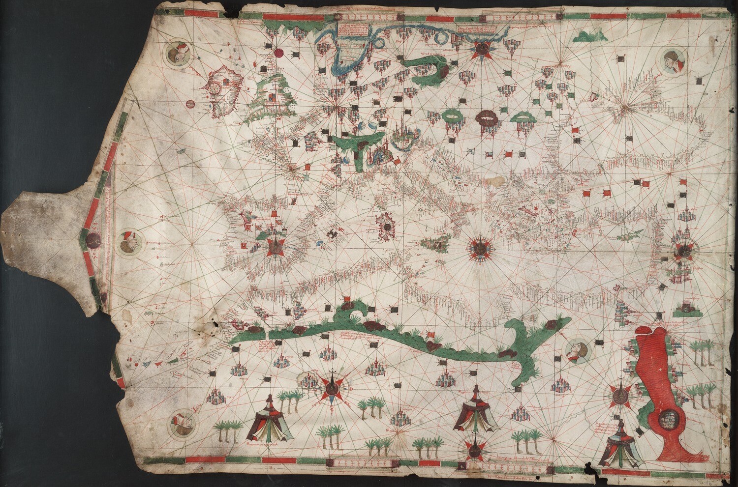
The 1492 Aquilar map, the oldest dated Portuguese portolan chart in existence, dramatically demonstrates the world as Christopher Columbus and his crew would have seen it on their first voyage in 1492. Along with the world map of Hericus Marteullus (below), these maps indicate the real dangers Columbus faced and answer fundamental questions about his first voyage, such as why he thought the trip should have been much shorter and why he went north after hitting the island of Hispaniola, rather than circumnavigating it, as would have been the normal course with an island.
The Marcellus world map is a stunning rare survival of the pre-exploration world. One of the largest maps (too large to be displayed along with the portolan), it hangs in the reading room, which visitors will be welcome to visit. The map shows a very diffferent perspective than the portolans–it is based on the ancient maps composed by Ptolemy, transmitted to Europe by Arab scientists and geographers.
The Becarius portolan chart is far older than the Aquilar map, dated from 1403, but contains a crucial cartouche that describes how map makers such as Becarius composed these maps, particularly the use of oral knowledge from sailors used to accurately measure the distances between ports. For this reason, Becarius’s map is one of the most studied by cartographers.
The Ben Zara map is unique for entirely different reasons. Judah Ben Zara was one of a handful of Jewish cartographers in Europe that we know of and his religion had a profound effect on his maps and his life. Only three maps of his survive. The first map, now at X, was produced in Spain in 14xx. The second map, now at X, was made in Egypt, where Ben Zara had been forced to flee after all the Jews were expelled from Spain by Ferdinand wind Isabella in 1492. Abenzaras last surviving map, shown here, was produced in Palastine in 15xx. It is the only portolan made on goatskin in our collection and it seems likely an adaptation to a climate that did not support cows.
The infamous Vinland map will be shown, along with the material acquired with it that purported to support its authenticity in 1965. We will also demonstrate the work done by Yale scientists in 2019 to finally prove that the map was a fake. We will also show some recent forgeries acquired as such to allow historians and scientists to study the techniques forgers employ.
The earliest surviving account of Magellen’s circumnavigation of the world in 1522, called the Pigafetta after its author, Antonio Pigafetta.
Calendar of Events
Materials
The exhibit is organized by three different cases on two levels. On the Mezzanine Level there are 18 small vitrines and two large curved cases. On the entrance level there are two large flat cases. The flat cases contain the collection of large portolan maps. The curved cases explore Asian maps and the Vinland Map and other exampkes of forgery. The vitrines demonstrate the development of mapping in the ancient, medieval and early modern world surrounding the Mediterreanean.
The links below are designed so that visitors to the exhibit can scan a QR code on an exhibit case and be taken directly to the webpage linked to that case. There, visitors can use an assisted reading program to read the text in the case. Below the exhibit text are links to the materials in the Beinecke Library’s Digital Library and additional bibliography.
Exhibit Layout
Portolan Maps (Ground Floor)
Pre-1500 (South Flat Case)
Post-1500 (North Flat Case)
Asian Maps
Forged Maps
Maps in Books (Vitrines
Martellus
Asian Maps
Vinland Map Forgery
Vitrines
1.
Glossary
A chart is used as sea to help navigate and is prcipally concerned with water. A map represents land masses and may not have information about navigation.